


tour lac de der

JL GUILLEMOTE
User
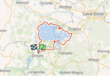

Length
48 km

Max alt
165 m

Uphill gradient
385 m
Km-Effort
53 km

Min alt
118 m

Downhill gradient
386 m
Boucle
Yes
Creation date :
2024-05-20 08:47:02.187
Updated on :
2024-05-26 17:03:04.384
4h45
Difficulty : Easy

FREE GPS app for hiking
 SityTrail
IGN / Geographical institutes
SityTrail Plus
The world is yours!
About
Trail Mountain bike of 48 km to be discovered at Grand Est, Haute-Marne, Rives Dervoises. This trail is proposed by JL GUILLEMOTE.
Positioning
Country:
France
Region :
Grand Est
Department/Province :
Haute-Marne
Municipality :
Rives Dervoises
Location:
Droyes
Start:(Dec)
Start:(UTM)
625505 ; 5375116 (31U) N.
Comments